


VARDZIA
Vardzia
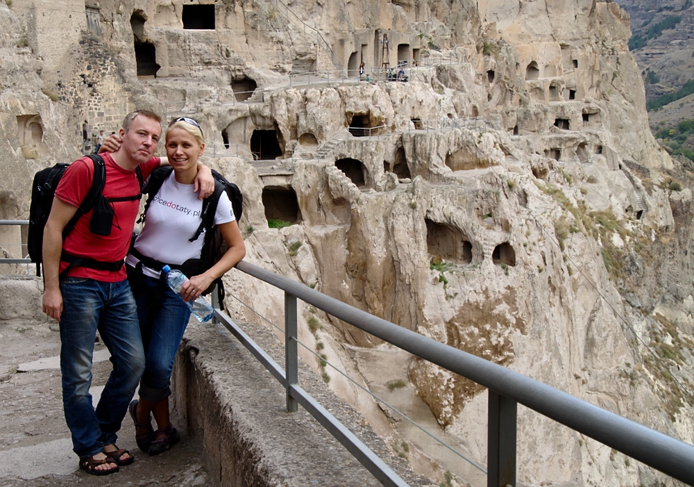
Vardzia (Georgian: ვარძია) is a cave monastery site in southern Georgia, excavated from the slopes of the Erusheti Mountain on the left bank of the Mtkvari River, thirty kilometres from Aspindza. The main period of construction was the second half of the twelfth century. The caves stretch along the cliff for some five hundred metres and in up to nineteen tiers. The Church of the Dormition, dating to the 1180s during the golden age of Tamar and Rustaveli, has an important series of wall paintings. The site was largely abandoned after the Ottoman takeover in the sixteenth century. Now part of a state heritage reserve, the extended area of Vardzia-Khertvisi has been submitted for future inscription on the UNESCO World Heritage List.

Soviet-era excavations have shown that the area of Vardzia was inhabited during the Bronze Age and indicated the reach of Trialeti culture. Cave settlements such as Uplistsikhe are known along the Mtkvari River from at least the fifth century BC, while rock cut architecture in the context of Georgian Christianity is known from Zedazeni and Garedzhi from the sixth century AD, and more locally from Vanis Kvabebi, Cholta and Margastani from the eighth century.[5] Four distinct building phases have been identified at Vardzia: the first during the reign of Giorgi III (1156-1184), when the site was laid out and the first cave dwellings excavated; the second between his death and the marriage of his successor Tamar in 1186, when the Church of the Dormition was carved out and decorated; the third from that date until the Battle of Basian c.1203, during which time many more dwellings as well as the defences, water supply, and irrigation network were constructed; while the fourth was a period of partial rebuilding after heavy damage in the earthquake of 1283.
History

Queen Tamar
A number of documentary sources supplement the knowledge derived from the site's physical fabric. The collection of chronicles known as the History of Georgia refers to Tamar erecting a church to house the icon of the Virgin of Vardzia after receiving divine help in her campaigns, before transferring the monastery from Upper or Zeda Vardzia. Tamar is said to have departed from Vardzia during her campaign against the Muslims, and her ensuing victory at Basian is celebrated in the Hymns in Honour of the Virgin of Vardzia by Ioane Shavteli. The History of Georgia also relates how Vardzia escaped the Mongol invaders in the 1290s. The Persian Safavid chronicler Hasan Bey Rumlu describes Vardzia as a "wonder", "impregnable as the wall of Alexander the Great", before recounting its sack by the Persians under Shah Tahmasp I in 1551; a near-contemporary note in the Vardzia Gospel tells of its repatriation from a Persian bazaar. After the arrival of the Ottomans in 1578, the monks departed and the site was abandoned
The greater Vardzia area includes also the early eleventh-century church at Zeda Vardzia and the tenth- to twelfth-century rock village and cave churches of Ananauri. The main lower site was carved from the cliff's central stratum of tufaceous breccia at an elevation of thirteen hundred metres above sea level. It is divided into an eastern and a western part by the Church of the Dormition. In the eastern part of the complex are seventy-nine separate cave dwellings, in eight tiers and with a total of 242 rooms, including six chapels, "Tamar's Room", a meeting room, reception chamber, pharmacy, and twenty-five wine cellars; 185 wine jars sunk into the floor document the importance of viticulture to the monastic economy. In the western part, between the bell tower and the main church, are a further forty houses, in thirteen tiers and with a total of 165 rooms, including six chapels, a refectory with a bakery, other ovens for baking bread, and a forge. Beyond the bell tower the complex rises to nineteen tiers, with steps leading to a cemetery. Infrastructure includes access tunnels, water facilities, and provision for defence
Church of the Dormition
The Church of the Dormition was the central spiritual and monumental focus of the site. Carved similarly from the rock, its walls reinforced in stone, it measures 8.2 metres (27 ft) by 14.5 metres (48 ft), rising to a height of 9.2 metres (30 ft). Both church and narthex are painted; these paintings are of "crucial significance in the development of the Medieval Georgian mural painting".[3] Its patron, Rati Surameli, is commemorated in a donor portrait on the north wall; the accompanying inscription reads "Mother of God, accept ... the offering of your servant Rati, eristavi of Kartli, who has zealously decorated this holy church to your glory".[5] On the same north wall are portraits of the royal founders, Giorgi III and Tamar; she lacks the ribbon that is the attribute of a married woman and her inscription includes the formula "God grant her a long life", while that of Giorgi does not; this helps date the paintings to between Giorgi's death in 1184 and Tamar's marriage in 1186.[5] Episodes from the life of Christ occupy the vaults and upper walls in a sequence, starting with the Annunciation, followed by the Nativity, Presentation in the Temple, Baptism, Transfiguration, Raising of Lazarus, Triumphal Entry into Jerusalem, Last Supper, Washing of the Feet, Crucifixion, Harrowing of Hell, Ascension, Descent of the Holy Spirit, and Dormition (the church is sometimes known as the Church of the Assumption, which corresponds with the Orthodox Feast of the Dormition).[5][7] At a lower level, more accessible as intercessors, are paintings of saints and stylites. On the rear wall of the sanctuary, behind the altar, are Twelve Church Fathers. In the narthex are scenes of the Last Judgment, Bosom of Abraham, Angels bearing a Medallion with the Cross, and three scenes from the life of Saint Stephen; other paintings were lost in the 1283 earthquake.[5] The paintings are not frescoes, but executed in secco, and "testify to contacts with the Christian Orient and the Byzantine world, but applied using local artistic traditions"
Management
Since 1985 the site has formed part of the Vardzia Historical–Architectural Museum-Reserve, which includes forty-six architectural sites, twelve archaeological sites, and twenty-one sites of monumental art.[2][6] In 1999 Vardzia-Khertvisi was submitted for inscription on the UNESCO World Heritage List as a Cultural Site in accordance with criteria ii, iii, iv, v, and vi.[6] In their evaluation, advisory body ICOMOS cited Göreme in Cappadocia as the closest comparandum amongst cave monastery sites of international significance.[6] In 2007 Vardzia-Khertvisi was resubmitted as a mixed Cultural and Natural Site in accordance also with criterion vii.[3] From 2012, conservation of the wall paintings in the Church of the Dormition is to be carried out by the Courtauld Institute of Art in conjunction with the National Agency for Cultural Heritage Preservation of Georgia and Tbilisi State Academy of Arts.

Borjomi
Borjomi
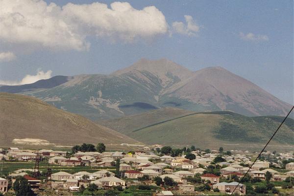
Borjomi (Georgian: ბორჯომი) is a resort town in south-central Georgia with a population estimated at 14,445. It is one of the districts of the Samtskhe-Javakheti region and is situated in the northwestern part of the region in the picturesque Borjomi Gorge on the eastern edge of the Borjomi-Kharagauli National Park. The town is famous for its mineral water industry (which is the number one export of Georgia), the Romanov summer palace in Likani, and the World Wide Fund for Nature-site Borjomi-Kharagauli National Park. Borjomi mineral water is particularly well known in those countries which were part of the former Soviet Union; the bottling of mineral water is a major source of income for the area. Because of the supposed curative powers of the area's mineral springs, it is a frequent destination for people with health problems. Borjomi is also home to the most extensive ecologically-themed amusement park in the Caucasus.

Borjomi
History
n the Middle Ages, the area of what is now Borjomi was part of the Tori province. It was populated by a series of forts guarding the strategic crossroad of routes leading to the western, eastern, and southern provinces of Georgia. Three important forts – those of “Gogia”, “Petra”, and “Sali” – still overlook the town from nearby hills. From the 16th century into the 19th, the area belonged to the noble family of Avalishvili, but was largely depopulated as a result of Ottoman inroads.
After the Russian annexation of Georgia, the Borjomi area began to revitalize. The toponym Borjomi is first recorded in 1819. The town and its surroundings were placed under the Russian military authorities. Borjomi began receiving soldiers in the 1820s. Buildings and baths began going up in the 1830s. Early in the 1840s, when the Russian Viceroy of the Caucasus Yevgeni Golovin brought his daughter down to partake of the cure, he expedited the official transfer of the waters from the military to civil authorities. The viceroy Mikhail Vorontsov, fascinated by local landscape and mineral waters, made Borjomi his summer residence and refurnished it with new parks. Its warm climate, its mineral water springs, and its forests made Borjomi a favorite summer resort for the aristocracy, and gave it its popular name of “the pearl of Caucasus.” In the 1860s, new hotels were built, and an administration for mineral waters was established. In 1871, Borjomi was bestowed upon the royal family member, Grand Duke Mikhail Nikolayvich, then the viceroy of the Caucasus. In the 1890s, Mikhail’s son, Nikolay, built a park and a chateau at Likani, at the western end of Borjomi. The bottled mineral waters began to be extensively exported. The town grew significantly at the expanse of Russian migrants and, in 1901, the number of ethnic Russian inhabitants (2,031) outstripped the native Georgians (1,424) for the first time.

Borjomi
Following the Red Army invasion of Georgia in 1921, the Soviet regime confiscated all aristocratic mansions and turned them into sanatoria, frequented by the Communist party elite. Despite significant damage caused by a flood on April 18, 1968, Borjomi continued to grow throughout the Soviet era. The post-Soviet years of political and economic crisis hindered development of the area, but it remained a popular destination for internal tourism. In the 2000s, a growing government and private investment into tourism and municipal infrastructure helped Borjomi recover from a decade of decay.
Borjomi, together with Bakuriani, was named by Georgia as an applicant city for the 2014 Winter Olympics on June 22, 2005, but it was eliminated as a candidate by the International Olympic Committee on June 22, 2006.

BAKURIANI
Bakuriani
Bakuriani (Georgian: ბაკურიანი) is a skiing resort in the Borjomi district of Georgia. It is located on the northern slope of the Trialeti Range, at an elevation of 1,700 meters (5,576 feet) above sea level.

BAKURIANI
The region around Bakuriani is covered by coniferous forests (mainly made up of spruce). The resort lies 30 km (19 mi) from Borjomi and is located within the so-called Bakuriani Depression/caldera. The resort is connected with Borjomi by an electrified narrow-gauge railway. The present-day area of the town was built up by the lava flows from the Mukheri volcano. The highest mountain of the resort used for skiing is called Mount Kohta at around 2,200 meters (7,216 feet) above sea level.
The climate of Bakuriani is transitional from humid maritime to relatively humid continental. The winters are cold and experience significant snowfall while the summers are long and warm. Average annual temperature of the town is 4.3 degrees Celsius. The average temperature in January is -7.3 degrees Celsius while the average August temperature is 15 degrees Celsius. The annual precipitation is 734 mm (28.9 in). The depth of snow from December to March is 64 cm (25.2 in). Bakuriani is also home to the Botanical Garden of the Georgian Academy of Sciences.
It was the home town of luger Nodar Kumaritashvili, who died during event training on the first day of the 2010 Winter Olympics in Vancouver, Canada. He lived in Bakuriani for much his life, and the street he lived on was named in his honor after his death. Georgia's flag-bearing athlete at the opening ceremony, alpine skiier Iason Abramashvili, also resides there; he has decided to compete to honor Kumaritashvili's memory.
The 37 km Borjomi - Bakuriani rail line uses 912 mm track gauge.
A few km south of Bakuriani lies the trajectory of the Baku–Tbilisi–Ceyhan pipeline.
The 37 km Borjomi - Bakuriani rail line uses 912 mm track gauge.
A few km south of Bakuriani lies the trajectory of the Baku–Tbilisi–Ceyhan pipeline.
.svg/800px-Samtskhe-Javakheti_in_Georgia_(Georgian_view).svg.png)
Samtskhe-Javakheti
Samtskhe-Javakheti (Georgian: სამცხე-ჯავახეთი), is a region (Georgian: Mkhare) formed in the 1990s in southern Georgia from the historical provinces of Meskheti (Samtskhe), Javakheti and Tori (Borjomi gorge). Akhaltsikhe is its capital. The region comprises six administrative districts: Akhaltsikhe, Adigeni, Aspindza, Borjomi, Akhalkalaki and Ninotsminda. There are 5 town, 6 townlets, 67 community and village sakrebulos (assemblies), and 268 villages in the region. Samtskhe-Javakheti is bordered by the regions of Adjara to the west, Guria and Imereti to the north, Shida Kartli and Kvemo Kartli to the north-east and to the east, and by Armenia and Turkey to the south and southwest.
The Baku-Tbilisi-Ceyhan oil pipeline, the South Caucasus natural gas pipeline, and the Kars–Tbilisi–Baku railway (under construction) pass through the region.
The Baku-Tbilisi-Ceyhan oil pipeline, the South Caucasus natural gas pipeline, and the Kars–Tbilisi–Baku railway (under construction) pass through the region.
History
The current division of Georgia into "regions"/Mkhare is a relatively new phenomenon introduced by the Shevardnadze government in the mid 1990s, partly as a response to the cessation of Abchasia and the South Ossetia-conflict. In this process, Samtskhe-Javakheti was basically formed from the two traditional provinces of Samtskhe and Javakheti
Meskheti
The ancient tribes of Meskhi (or Moschi) and Mosiniks are the first known inhabitants of the of the area. Some scholars credit the Mosiniks (or Mossynoeci) with the invention of iron metallurgy. From the 2nd millennium to the 4th century BC, Meskheti was believed to be part of the Kingdom of Diaokhi, in the 4th century BC to the 6th century AD part of the Kingdom of Iberia. From the 10th to the 15th century it was part of the united Georgian Kingdom. In the 16th century Meskheti was integrated into the Ottoman Empire. From 1829 to 1917 it was a part of Russian Tbilisi Governorate (Tiflisskaia Gubernia), from 1918 to 1921 part of the Democratic Republic of Georgia, and from 1921 to 1990 part of the Georgian SSR. After independence from the USSR Meskheti was reinstalled as a province of Georgia, and later cast into the new Samtskhe-Javakheti region.
Akhalkalaki
Javakheti
In early sources, the region was recorded as Zabakha in 785 BC owned by the king Argishti I of Urartu as a conquered land. In the 1st century AD king of Kartli (Georgian Kingdom) Parsman I (Kveli) managed to take Javakheti (Javakhk). In the 5th century during the ruling of Vakhtang V (Gorgaslani) Javakheti (Javakhk) was an ordinary province of Georgia and after his death his second wife the Byzantinian princess settled in Tsunda (part of Javakheti). Javakheti was an important part of the Kingdom of Kartli. In the 11th century Akhalkalaki became the center of upper Javakheti, and Tmogvi the center of lower Javakheti. Under the Georgian Kingdom (11th-13th centuries), Javakheti bridges, churches, monasteries, and royal residences (Lgivi, Ghrtila, Bozhano, Vardzia) were constructed. From the 13th century, Javakheti included the territories of Palakatsio (modern Turkey) and part of Meskheti. In the 15th century, Javakheti was governed by Samtskhe-Saabatago. In the 16th century, it became part of the Ottoman Empire.[citation needed] The Georgian population of Javakheti was displaced to inner regions of Georgia - part to the Imereti, and another to the Kartli. Those who remained in the place became Muslims.
As a result of the struggles of the Russian Empire with the Ottomans, Russian authorities settled Christian Armenians and Greeks in the area afer 1828.[1] Armenian refugees from the Armenian genocide in the Ottoman Empire came in the early 20th century. Also a large number of Russian Doukhobor sect members settled the region.
As a result of the struggles of the Russian Empire with the Ottomans, Russian authorities settled Christian Armenians and Greeks in the area afer 1828.[1] Armenian refugees from the Armenian genocide in the Ottoman Empire came in the early 20th century. Also a large number of Russian Doukhobor sect members settled the region.
Expulsion of Meskhetian Turks
Meskhetian Turks are the former Muslim inhabitants of Meskheti (now known as Samtskhe) in Georgia, along the border with Turkey. From November 15 to November 25, 1944, they were deported in cattle-trucks to Central Asia by order of Stalin and settled within an area that overlaps the boundaries of the modern nations of Kazakhstan, Kyrgyzstan, and Uzbekistan. Today, many are still dispersed across those countries. Of the 100,000 forcibly deported, a total of 10,000 perished.
Population
The majority of the inhabitants in Javakheti is ethnically Armenian, with a small Georgian minority. Armenian population are a majority in Ninotsminda and Akhalkalaki cities.[3] They speak Georgian, Armenian and Russian.
Politics
According to the 2002 census, ethnic Armenians (chiefly concentrated in Akhalkalaki and Ninotsminda districts), are the majority in the region, making up about 54% of the population.[5] They share the region with Pontian Greeks, Ossetians and Georgians. According to an NGO source, they are underrepresented in all spheres of public life, especially government. Only three of the governor’s 26 staff members are Armenian (11 per cent)[citation needed]. The same is true for the territorial departments of the various ministries. For instance, only sixteen of 82 staff members (19.5 per cent) of the tax department in Samtskhe-Javakheti are Armenian.[6] Lack of dialogue between local Armenians and the national government in Tbilisi adds to perceptions of discrimination and alienation.[7] There have been demonstrations, police brutality and killings in this regio
Tourist attractions
Two of the major tourist attractions are the cave monasteries of Vardzia (which was founded by Queen Tamar in 1185), Vanis Kvabebi (which dates from the 8th century) and Khertvisi fortress.They are located near the town of Aspindza.
No comments:
Post a Comment