


KUTAISI
Kutaisi
Kutaisi (Georgian: ქუთაისი; ancient names: Aea/Aia, Kotais, Kutatisi, Kutaïssi) is Georgia's second largest city, legislative capital, and the capital of the western region of Imereti. It is 221 km west of Tbilisi.
Geography
Kutaisi is located along both banks of the Rioni River. The city lies at an elevation of 125-300 meters (410-984 feet) above sea level. To the east and northeast, Kutaisi is bounded by the Northern Imereti Foothills, to the north by the Samgurali Range, and to the west and the south by the Colchis Plain.
Landscape
Kutaisi is surrounded by deciduous forests to the northeast and the northwest. The low-lying outskirts of the city have a largely agricultural landscape. The city centre has many gardens its streets are lined with high, leafy trees. In the springtime, when the snow starts to melt in the nearby mountains, the storming Rioni River in the middle of the city is heard far beyond its banks.
Climate
The climate in Kutaisi is humid subtropical with a well-defined on-shore/monsoonal flow (characteristic of the Colchis Plain) during the Autumn and Winter months. The summers are generally hot and relatively dry while the winters are wet and cool. Average annual temperature in the city is 14.5 degrees Celsius. January is the coldest month with an average temperature of 5.3 degrees Celsius while July is the hottest month with an average temperature of 23.2 degrees Celsius. The absolute minimum recorded temperature is −17 degrees Celsius and the absolute maximum is 44 degrees Celsius. Average annual precipitation is around 1,530 mm (60.24 in). Rain may fall in every season of the year. The city often experiences heavy, wet snowfall (snowfall of 30 cm/12 inches or more per single snowstorm is not uncommon) in the winter, but the snow cover usually does not last for more than a week. Kutaisi experiences powerful easterly winds in the summer which descend from the nearby mountains
History
Kutaisi was the capital of the ancient Kingdom of Colchis. Archeological evidence indicates that the city functioned as the capital of the kingdom of Colchis as early as the second millennium BC. Several historians believe that, in Argonautica, a Greek epic poem about Jason and the Argonauts and their journey to Colchis, author Apollonius Rhodius considered Kutaisi their final destination as well as the residence of King Aeëtes. From 978 to 1122 CE, Kutaisi was the capital of the united Kingdom of Georgia, and from the 15th century until 1810, it was the capital of the Imeretian Kingdom. In 1508, the city was captured by Selim I, who was the son of Bayezid II, the sultan of the Ottoman Empire.
During the seventeenth century, Imeretian kings made many appeals to Russia to help them in their struggle for independence from the Ottomans. All these appeals were ignored as Russia did not want to spoil relations with Turkey. Only in a reign of Catherine the Great in 1768 troops of general Gottlieb Heinrich Totleben were sent to join the forces of King Heraclius II of Georgia, who, with Russia, hoped to reconquer the Ottoman-held southern Georgian lands. Totleben helped King Solomon I of Imereti to recover his capital, Kutaisi, on August 6, 1770.
Finally, the Russian-Turkish wars ended in 1810 with the annexation of the Imeretian Kingdom by the Russian Empire. The city was the capital of the Gubernia of Kutaisi, which included much of west Georgia. In March 1879, the city was the site of a blood- libel trial that attracted attention all over Russia; the ten accused Jews were acquitted.[2]
Kutaisi was a major industrial center before Georgia's independence in 1991. Independence was followed by the economic collapse of the country, and, as a result, many inhabitants of Kutaisi have had to work abroad. Small-scale trade prevails among the rest of the population.
The city had a massive Soviet war memorial for the Georgians killed in World War II. On December 18, 2009, a private demolition company working for the Georgian government demolished the monument to make room for a parliament building, despite massive protest from Russia and the Georgian opposition. Safety regulations were violated, resulting in flying chunks of concrete hitting civilian population centers. A woman and her daughter were killed in the courtyard of their home, and four other people were critically injured.[3]
In 2011 Mikheil Saakashvili, the president of Georgia, signed a constitutional amendment relocating the parliament to Kutaisi.[citation needed]
On 26 May 2012, Saakashvili inaugurated the new Parliament building in Kutaisi. This was done in an effort to decentralise power and shift some political control closer to Abkhazia, although it has been criticised as marginalising the legislature, and also for the demolition of a Soviet War Memorial formerly at the new building's location.

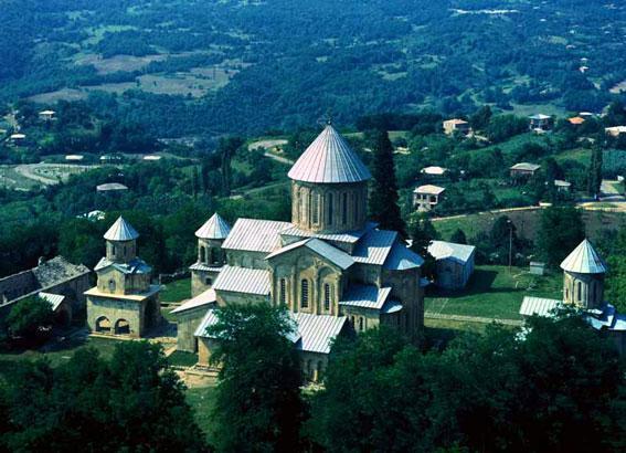
Bagrat Cathedral
Imereti
The region of Imereti is situated along the middle and upper end of the Rioni river. The main city of the region is Kutaisi. Imereti is divided into Zemo (upper) and Kvemo (lower) Imereti. It borders the Likhi Mountain Range to the east, Tskhenistskali River to the west, the Caucasus Mountains to the north and Meskheti or Persati Mountains to the south. The lowlands of Imereti are mostly covered with Colchis low brush, forests, oaks, groves, and meadows. The mountainous parts of Imereti are mainly Colchis deciduous forests. The forests of Imereti are rich with animals and birds. Zekari, Ajameti and Kharagauli forests are populated with bears, wolves, martens, foxes, jackals, badgers, deer, rabbits, squirrels and bobcats. Some of the most common birds are: jay, cuckoo, nightingale, woodcock, hoopoe as well as some rare birds.

Climate
The Imereti lowland is part of the Kolkheti Valley with a sub-tropical sea climate. Winter here is mild, while the summer is hot. The average annual temperature is 11-15 degrees Celsius. The climate of upper Imereti is humid sub-tropical, with winters that are colder and have more precipitation.
GELATI
Culture and traditions
Imereti has always been known for its highly developed spiritual and family culture, believed to be influenced by the Colchis. Imereti developed viticulture, cattle-breeding, poultry-farming, bee-keeping, production of dairy products and gardening. Some of the most important agricultural sectors were viticulture, the cultivation of corn crops, and orchards. This area of Georgia has some unique wine varieties and there is evidence that wine production here dates back to ancient times. Proof of their dedication to the craft of wine making can be seen in the ancient wine jars, grape presses, winery rules and traditions of the Georgian table in Imereti. Feasting and fun are an integral part of life for the people of Imereti, while singing is an essential element of the banquet table. The tradition of modern songs with guitar accompaniment in Georgia originated in Imereti. Even now, folk polyphonic, lyric and joyful songs are performed during festivities in Imereti. A number of folk traditions and rituals have been preserved in Imereti. People have special traditions for celebrating Giorgoba (St. George’s Day), Mariamoba (St. Mary’s Day), Barbaroba (St. Barbara’s day), New Year and Christmas, funerals and memorials, weddings, and births. The villages of Imereti are colorful and have a special charm. One example is the village of Khani, located by Zekari Cross. Archeological artifacts dating back to the second millennium were discovered in Khani. Over the centuries the village has been destroyed several times, but its inhabitants always managed to rebuild it. Of particular interest is the village of Koreti, located 16 km from Sachkhere. The village, as well as its surrounding territory, has been inhabited since ancient times. This village is especially interesting for the large number of cellars and viticulture it has. In the 19th century the village’s families united and started wine production together. The ancient part of the village still has over a dozen very old wine cellars covered with roof tiles, with presses for grapes, bread bakeries, wine jars and other inventory for wine-making. Shrosha is the ancient home of pottery in Georgia, known since ancient times for its masterpieces. Georgian red soil, useless for agriculture, is perfect for making pottery. There was a factory built in Shrosha at the beginning of the 20th century to produce ceramic items, but traditional methods passed down through generations are still popular. Kvevri (beet-shaped wine vessels made of clay) are usually stored in the ground to keep wine cool during summer and therefore increase its lifespan.

Cuisine
The people of Imereti are very hospitable. Guests are often welcomed with supras (large dining parties) where they are treated to a variety of dishes. Walnuts are widely used in their cuisine, which adds a wonderful flavor to local products. Most Imeretian food is prepared in clay pots and cooked with herbs. Some of the special dishes of Imereti are: khachapuri (baked cheese bread), satsivi (chicken or turkey in a spiced walnut sauce), gomi (Georgian grits), matsoni (fresh yoghurt), and pkhali (ground spinach mixed with herbs and spices).

Protected areas
The Borjomi-Kharagauli National Park: The Borjomi-Kharagauli National Park is one of the largest in Europe - it covers more than 76,000 hectares of native forest and sub-alpine and alpine meadows, and is home to rare species of flora and fauna. It is the first National Park in the Caucasus to meet international standards. The park was established in 1995 and officially opened in 2001. Rare and endemic species noted in Georgia’s Red Data Book (a list of endangered and protected species) can be found in the territory of the Borjomi-Kharagauli National Park. The fauna of Borjomi-Kharagauli is diverse. This National Park has a wonderful array of mammal inhabitants. Among the large carnivores it is possible to find gray wolves, lynx, and brown bears here. Among hoofed animals, roe deer and wild boar can frequently be seen on the national park’s territory. For native birds of Borjomi-Kharagauli National Park the following rare species can be identified: the golden eagle, griffon vulture, black vulture, and Caucasian black grouse. The forests of the Kharagauli part of the Borjomi-Kharagauli National Park are a combination of dark coniferous, deciduous and mixed forests. Visitors can observe amazingly different life and traditions in the territories bordering the Borjomi-Kharagauli National Park, due to the interesting ethnographical diversity, which is additionally impressive for visitors of the park.

Sataplia Reservation: Sataplia Reservation is located very close to Kutaisi, on Sataplia Mountain, with a total area of 354 hectares. It has mountains and hills and is almost fully covered by the Colchis Forest. There are numerous grotto caves, although the most interesting one is “Sataplia Cave”, located on Samgurali slope. It has a corridor system with branches and halls. The cave is rich with stalactites, stalagmites and mineral rock curtains. The total length of the cave measures 600 meters. It has a stream flowing inside, which has carved out this cave over the past 30 million years. Over 200 footprints from dinosaurs have been discovered here, located on the stones in two rows. To the north of Sataplia cave there is a flowering meadow on the cliff with a number of bee colonies. This was the reason for naming this area Sataplia (“the place of honey”). When you go, be sure to check out the local museum.
Ajameti Protected Area: Ajameti Managed Nature Reserve is located in the Baghdati district, 265 km from Tbilisi and 15 km from Kutaisi on the Rioni plain and consists of three districts: Ajameti, Vartsikhe and Sviri. The total area of the Managed Nature Reserve is 4848 ha, out of which 4738 ha is covered with forest. What makes Ajameti forest unique is that in the Kolkheti lowland it is nearly the only place where subtropical mixed forests have been preserved in their original conditions. Some of the trees are more than 250 years old, and the century-old oaks are frequently found. Ajameti is somewhat weak in animal and bird species. Among mammals one can see hare, red fox, jakal, squirrel, weasel, dormouse and badger here. The largest animal of Ajameti is the roe-deer. The following animals of the Red List of Georgia can be found in the Ajameti Nature Reserve: Leisler’s bat, Caucasian squirrel, common dormouse, Forest dormouse and Caucasian otter. More than 60 species of birds are registered in the Ajameti Managed Nature Reserve. Out of them only twenty-one nest in the oak forest, the others appear in Ajameti while migrating or spending winter there.

Katskhi pillar
The Katskhi pillar (Georgian: კაცხის სვეტი, kac'xis svet'i) is a natural limestone monolith located at the village of Katskhi in western Georgian region of Imereti, near the town of Chiatura. It is approximately 40 metres (130 ft) high, and overlooks the small river valley of Katskhura, a right affluent of the Q'virila.
The rock, with visible church ruins on its top surface of around 150 m2, has been venerated by locals as the Pillar of Life, symbolizing the True Cross, and has become surrounded by legends. It remained unclimbed by researchers and unsurveyed until 1944 and was more systematically studied from 1999 to 2009. These studies revealed the early medieval hermitage, dating from the 9th or 10th century. A Georgian inscription paleographically dated to the 13th century suggests that the hermitage was still extant at that time.[1] Religious activity associated with the pillar started to revive in the 1990s and the monastery building had been restored within the framework of a state-funded program by 2009.
The rock, with visible church ruins on its top surface of around 150 m2, has been venerated by locals as the Pillar of Life, symbolizing the True Cross, and has become surrounded by legends. It remained unclimbed by researchers and unsurveyed until 1944 and was more systematically studied from 1999 to 2009. These studies revealed the early medieval hermitage, dating from the 9th or 10th century. A Georgian inscription paleographically dated to the 13th century suggests that the hermitage was still extant at that time.[1] Religious activity associated with the pillar started to revive in the 1990s and the monastery building had been restored within the framework of a state-funded program by 2009.
Architecture
The Katskhi pillar complex, in its current state, consists of a church (currently named in honor of Maximus the Confessor), a crypt (burial vault), three hermit cells, a winecellar, and a curtain wall on the uneven top surface of the column. At the base of the pillar are the newly built church of Simeon Stylites and ruins of an old wall and belfry.
The church of St. Maximus the Confessor is located at the south-easternmost corner of the top surface of the Katskhi pillar. A small simple hall church design with the dimensions of 4.5 × 3.5 m., it is a modern restoration of the ruined medieval church built of stone. Beneath and south of the church is an elongated rectangular crypt with the dimensions of 2.0 × 1.0 m., which had served as a burial vault. Digs at the ruined winecellar revealed eight large vessels known in Georgia as k'vevri. Also of note is a rectangular cellar grotto with the entrance and two skylights—on the vertical surface of the rock, some 10-metre (33 ft) below the top. At the very base of the pillar there is a cross in relief, exhibiting parallels with similar early medieval depictions found elsewhere in Georgia, particularly at Bolnisi.
History
In historical records, the Katskhi pillar is first mentioned[1] by the 18th-century Georgian scholar Prince Vakhushti, who reports in his Geographic Description of the Kingdom of Georgia: "There is a rock within the ravine standing like a pillar, considerably high. There is a small church on the top of the rock, but nobody is able to ascend it; nor know they how to do that."[5] No other written accounts of monastic life or ascents survive. A number of local legends surround the pillar. One of them has it that the top of the rock was connected by a long iron chain to the dome of the Katskhi church, located at a distance of around 1.5 km from the pillar.
In July 1944 a group led by the mountaineer Alexander Japaridze and the writer Levan Gotua made the first documented ascent of the Katskhi pillar. Vakhtang Tsintsadze, an architecture specialist with the group, reported in his 1946 paper that the ruins found on top of the rock were remains of two churches, dating from the 5th and 6th centuries and associated with a stylite practice, a form of Christian asceticism. Since 1999, the Katskhi pillar has become the subject of more systematic research. Based on further studies and archaeological digs conducted in 2006, Giorgi Gagoshidze, an art historian with the Georgian National Museum, re-dated the structures to the 9th–10th century. He concluded that this complex was composed of a monastery church and cells for hermits. Discovery of the remnants of a wine cellar also undermined the idea of extreme ascetism flourishing on the pillar. In 2007, a small limestone plate with the asomtavruli Georgian inscriptions was found, paleographically dated to the 13th century and revealing the name of a certain "Giorgi", responsible for the construction of three hermit cells. The inscription also makes mention of the Pillar of Life, echoing the popular tradition of veneration of the rock as a symbol of the True Cross.
Religious activity started to revive in 1995, with the arrival of the monk Maxim, a native of Chiatura. Between 2005 and 2009, the monastery building on the top of the pillar was restored with the support of the National Agency for Cultural Heritage Preservation of Georgia.[3] The rock is now accessible through an iron ladder running from its base to the top.
No comments:
Post a Comment